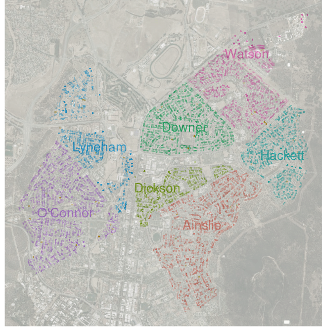
Using Google's Static Maps and Geocoding API
The complete code for this post is on GitHub.
R package
rjsonis used to parse the geocoding output.
Geocoding Requests
Using Google’s Geocoding API is very simple. From the documentation requests should be of the following form:
http://maps.googleapis.com/maps/api/geocoding/[output]?[parameters]where output is the output format (either json or xml) and parameters include required and optional values separated by an ampersand (&).
The two required parameters:
-
a location value such as an
address -
a
sensorvalue,trueorfalse, indicating whether or not the geocoding request come from a device with a location sensor
For example, for the address “West 35th, New York”, we could send the following request:
http://maps.googleapis.com/maps/api/geocoding/json?address=west+35th+new+york&sensor=falseSo, wraping the request in an R function, for a list/vector of addresses, we can retrive the geocoding data
GetGoogleMapJSON <- function(address) {
    URL <- paste("http://maps.googleapis.com/maps/api/geocode/",
                 "json?address=", gsub(" ","\\+", address),
                 "&sensor=false", sep="")
    tryCatch(fromJSON(paste(readLines(URL), collapse="")),
             error=function(e) e)
}

GoogleMAPJSON <- lapply(addresses, GetGoogleMapJSON)
Note that there is a limit on the API of 2500 request per day, more than that and the results field in the JSON output is empty and the status field contains an "OVER_QUERY_LIMIT" value.
Because of this limit, there is an exception handling step in GetGoogleMapJSON so that in the case of something like a connection error, we don’t lose previous successful requests.
Now that we have a list of geocoding data for each address extracting desired attributes is simple a matter of using sapply/lapply, for example, to extract the latitude and longitude
lat <- sapply(GoogleMapJSON,
    function(x) tryCatch(x[[1]][[1]]$geometry$location$lat,
                         error=function(e) NA))
lng <- sapply(GoogleMapJSON,
    function(x) tryCatch(x[[1]][[1]]$geometry$location$lng,
                         error=function(e) NA))
So we now, consolidating the data into a data frame:
head(dat)
#                                        Address NrBed NrBath PropType   Price
# 1               5 Faunce Cr ACT 2602 AUSTRALIA     4      2    House 1130000
# 2           33 Mackennal St ACT 2602 AUSTRALIA     3      1    House  670000
# 3           60 Clianthus St ACT 2602 AUSTRALIA     3      1    House  698000
# 4             40 Raymond St ACT 2602 AUSTRALIA     3      1    House  730000
# 5 22/21 Cossington Smith Cr ACT 2602 AUSTRALIA     3      1     Unit  420000
# 6              36  Negus Cr ACT 2602 AUSTRALIA     4      2    House  770000
#         Date status
# 1 2013-06-15     OK
# 2 2013-06-15     OK
# 3 2013-06-15     OK
# 4 2013-06-13     OK
# 5 2013-06-11     OK
# 6 2013-06-08     OK
#                                                  addressGoogle   suburb
# 1              5 Faunce Crescent, O'Connor ACT 2602, Australia O'Connor
# 2             33 Mackennal Street, Lyneham ACT 2602, Australia  Lyneham
# 3            60 Clianthus Street, O'Connor ACT 2602, Australia O'Connor
# 4               40 Raymond Street, Ainslie ACT 2602, Australia  Ainslie
# 5 22/21 Cossington Smith Crescent, Lyneham ACT 2602, Australia  Lyneham
# 6                36 Negus Crescent, Watson ACT 2602, Australia   Watson
#          lat        lng
# 1 -35.266748 149.116408
# 2 -35.247003 149.122385
# 3 -35.251226 149.115978
# 4 -35.255091 149.154808
# 5 -35.241862 149.125098
# 6 -35.233724 149.161682

R code for this map on GitHub.